Showing posts with label Spring Street. Show all posts

Tuesday, November 24, 2015

(An Early) Winter Ode to Spring...Street, Los Angeles, Cal.

Photo taken in 2010
Spring Street was named for Trinidad Serafina Ortega, a girl who just turned 17 when Ord and Hutton were situated in Ciudad de Los Angeles conducting the city's first American land survey.

Her nickname was "La Primavera," and the survey listed Calle Primavera or Spring Street.  Below is a portion of Henry Hancock's 1857 survey of the city's confirmed limits but shows Primavera misspelled:

Courtesy of the Seaver Center for Western History Research (GC1310-[0856])

Several historical references state that she was the Santa Barbara girlfriend of surveyor Lieutenant Edward O.C. Ord, but this blog posting disputes that observation.  The L.A. Times also linked her romantically to Benjamin Wilson ("Don Benito" born in 1811 from Tennessee and traveled with the Workman-Rowland Party to California in 1841).  Their paths probably crossed, but it seems unlikely that Wilson wooed the 17-year old; he was widowed in 1849 when his 21-year old wife Ramona Yorba died after a five-year marriage; he soon remarried to Margaret Hereford; one of their grandkids was George S. Patton (the military general).

Probably Trinidad was a beloved girl in the small town, and her nickname was a generally known term of endearment.

Spanish Lineage

Trinidad was the great-granddaughter of a Guanajuato, New Spain soldier Jose Francisco Ortega, who traveled to California with Franciscan priest Junipero Serra and Captain Gaspar Portola.  He was a pathfinder or scout who helped to establish the sites of missions in upper California, and he is known as the discoverer of today's San Francisco Bay.

Her heritage was linked more directly to other Californios.  Born in San Diego in the year 1832, her father Jose Joaquin Geronimo Ortega was a ranchero of SantaYsabel.  Trinidad's mother was Maria Casimira Pico, a younger sister of Pio Pico.  Trinidad was the youngest of six children.

In 1849, Trinidad may have been staying in her uncle's household instead of San Diego.  It is not known whether the dirt road was already referred to as La Primavera, or if Ord picked up this information from local townspeople while surveying and named the street accordingly.  This blogger once came across a reference stating that Ord was rooming in the Ortega house during the summer of 1849.  (Pio Pico's official residence was sold in May, 1849 to Benjamin Wilson.)

Pio Pico, the last governor of California under Mexican rule, with
his wife Maria Alvarado and their nieces Maria Anita Alvarado (far left)
and Trinidad Ortega (far right), in 1852
(GPF.0350 courtesy of the Seaver Center)
Trinidad Gets Married

Edward Ord had reported to Governor Bennet Riley (military governor of the California Territory in 1849) that the local women preferred the "newcomers" to the Mexican men.  Californio women had been marrying inter-culturally with European and American men for many years by the time of Ord's observation.  Trinidad, though, did not.  She married into the De la Guerra family, a wealthy and powerful Spanish family of Santa Barbara.  Her husband, Miguel De la Guerra was the fifth son of thirteen children.  She bore him eight children before he died in 1878.


Trinidad De La Guerra about 1864
(P-157-2-78 Courtesy of the Seaver Center)
At a time when the world was much smaller, Trinidad and Ord later became related by marriage.  Ord's physician brother James Lycurgus Ord married in 1856 to Trinidad's widowed sister-in-law, Maria de las Angustias De la Guerra.

Marriage also provides a link between two historic streets (Spring and Olvera):  Trinidad's oldest sister Maria Refugio married Agustin Olvera - second marriages for both widowed Maria Refugio and Agustin.
 
Race, Politics, and Irony at Play with Trinidad's Brother-In-Law
 
Pablo De la Guerra, Trinidad's brother-in-law, was one of the signers of the California Constitution, as were a good number of Californios.  He even served a year as Acting Lieutenant Governor of California in 1861.  In 1869 he ran for the elected office of District Judge of the First Judicial District.  Opponents filed suit on the grounds of disqualification, arguing that De la Guerra was not a citizen.  The state Supreme Court ruled in favor of De la Guerra.  (Though he was born in Santa Barbara, Alta California, the treaty resulting from the war of 1846-1848 granted all Californios the option of automatic citizenship of the new regime.)
 
Glamour and Romance

20th century local society remembered Trinidad, who passed away in 1903.  Club ladies honored her through costumed reenactments.  In 1931, a pivotal year for Los Angeles, being the 150th anniversary of the founding of the city, the Times published this glamorous illustration:


Tuesday, March 24, 2015

Ord Street: the Soldier, the Surveyor, the Civil War Hero and a Royal Lineage

Ord Street, in present day L.A.'s Chinatown, is a minor, ordinary side street, a brief stretch with no particular visual appeal (with the exception of Philippe's restaurant, home of the French-dipped sandwich).  It begins an ascent at Philippe's, then levels off, but takes a sharp final ascent before it merges with Yale Street.  The street has been mentioned on this blog not once, but twice, prior to this posting.


The Ord name is well-known in its association with the first American survey of the city (Plan de la ciudad de Los Angeles) created by the 30-year old Lieutenant Edward Otho Cresap Ord and his 21-year old assistant William Rich Hutton during the summer of 1849.

In the cities of San Francisco and Monterey, and the U.S. capitol Washington D.C., each has a street named Ord, most likely for Edward.

Update 11.9.2024:  For an in-depth look at Ord's impact on Los Angeles, consult James Tejani's A Machine to Move Ocean and Earth:  the Making of the Port of Los Angeles and America (W.W. Norton, 2024).

Sometime in the late 1880s or early 1890s L.A.'s Ord Street evolved from the former "Walters" street, providing Edward an eponymous tribute through a street name.  The Ord name would have popped up often in the public memory, particularly after the real estate boom of 1886-88 - all L.A. parcel descriptions would invariably include references to "Ord's Survey" (and the references appear on today's assessor maps). 

The street was, by the standard of the time, not in a prominent neighborhood - it was near Sonoratown; some of the old adobes still stood; and around the corner was a hub of prostitution activity.  The location was a choice one, nevertheless, a name designation appropriate because Lieutenant Ord surveyed this specific street (as Calle Alta) onto the historic map.


Image courtesy of the Seaver Center for Western History Research

The map originally drawn by Ord and Hutton no longer exists.  It was copied twice (through tracing) by Lothar Seebold for the price of $75.00 gold coin, which he completed in 1872.  The original may have been discarded after the official copies were finished.

J. Gregg Layne concluded in an article from the Quarterly Publication (Historical Society of Southern California) Vol. 17, No. 4 (December, 1935), pp. 139-142, that while Edward led a brilliant military career, "no act of his will place his name in the minds of men for all time more forcibly than his survey...".
Edward O.C. Ord (Image courtesy of the Seaver Center)

Lives and Careers of the Ord Family

A Royal Lineage

Edward was born in 1818 at Cumberland, Maryland, and his father was James Ord (c. 1789-1873).  Existing research supports the fact that James was the secret son of George IV and Maria Fitzherbert while George was the Prince of Wales (a morganatic union because Fitzherbert was outside of the royal class).  James immigrated from England in 1790 and never knew his true parents.

Ord Brothers

Edward's highly-educated siblings included brothers Pacificus Ord (b. 1816), Judge James Placidus Ord and Dr. James Lycurgus Ord.  Edward graduated from the United States Military Academy at West Point in 1839; James Placidus was elected into the Michigan legislature; James Lycurgus and Pacificus earned medical and law degrees respectively.  Edward, James and Pacificus spent career time in California as the escalating U.S. interest in Alta California and the eventual outcome of the war with Mexico placed the Ord brothers in pivotal points of California's transformative years.

Edward's first service was in 1840 during the Seminole Indian war in the Florida Everglades.  It was there that he was promoted from Second Lieutenant of the Third Artillery to First Lieutenant.  In 1847 he was sent with his regiment to California, on the USS Lexington from New York across Cape Horn.  Upon arrival he was stationed at the garrison at Monterey, where he spent a lot of time keeping an eye on the conquered Californians and Native Americans.  His brother James Lycurgus, had accompanied the regiment on contract as Surgeon.  Other siblings, Robert, William and Georgina, moved out to California as well.

The War with Mexico

The disputed boundaries of Texas escalated to war between the U.S. and Mexico by mid-year of 1846.  The greatest bloodshed, the rugged terrain met by the foot soldiers, and the atrocities against civilian Mexicans were found in Mexico, far from Alta California.  This included the noted battles of Buena Vista and Veracruz.  Amy S. Greenberg stated in the introduction to her book A Wicked War:  Polk, Clay, Lincoln and the 1846 U.S. Invasion of Mexico (New York:  Alfred A. Knopf, 2012) that this war "had the highest casualty rate of any American war.  Over 10 percent of the seventy-nine thousand American men who served in the war died, most from disease.  Mexican casualties are harder to estimate, but at least twenty-five thousand, most civilians, perished in the course of the war."

By the time Edward arrived in Alta California, a local peace treaty had been signed near Los Angeles (the Treaty of Cahuenga, January, 13, 1847).  He was a fortunate one, as American soldiers and volunteer units marched and held to the front lines much farther south in Mexico.

The U.S. vs. Californios

Pacificus moved to California in 1848 and held various positions of authority when a nascent government structure was taking shape in the earliest years of statehood - he was a member of the first California Constitutional Convention, 1849; he served as a justice of the state's Territorial Supreme Court.  In 1855, he was appointed U.S. Attorney for the Southern District of California and served until 1859.  As the attorney, he routinely filed appeals on behalf of the U.S. against the Californios - the Mexican landowners who relied on the terms of the Treaty of Guadalupe Hidalgo to prove and hold onto their former Mexican rancho lands.

Two cases in example - the Del Valles of Rancho San Francisco (in present day Ventura County) were fortunately financially able to retain attorneys to successfully hold onto their property; the good news came nearly three years later, in January, 1855.  By the fall of the same year, they received a printed form appeal notice issued by Pacificus, stating the decision of the "Commissioners is erroneous, and ought to be reviewed, reversed..."  The same situation confronted Bernardo Yorba and family with the challenge to their Rancho Santiago de Santa Ana (present day Orange County), as they began to fight an appeal issued in the summer of 1856.  Below is page 3 from the Del Valle appeal notice.


Image courtesy of the Seaver Center

The Survey and Ord's Time in California

The end of war along with a rising cost of living due to the California Gold Rush prompted young military men, including Edward, to seek supplemental income through surveying work.  Edward found work in the heart of the gold fields, slightly ahead of the teems of Forty-Niners soon to arrive.  One map in existence is the "Topographical Ske[tch] of the Gold and Quicksilver Dis[stricts] of California," completed by E.O.C.O. in July, 1848.  Edward also became assistant along with his friend Lieutenant William Tecumseh Sherman in the first survey of the newly founded city of Sacramento in 1849.

In 1848 California was under a military-ruled interim period before admission into the union.  Cities, including Los Angeles, were cash-strapped.  Anxious to sell land to generate revenue, the city needed a surveyed plan of the city.  Near the summer of 1849 the ayuntamiento (City Council) began to hire a surveyor.  Edward was one of the bidders for the job, though not the lowest bid.  He asked for $1,500 plus his choice of 10 lots and some other vacant lands.  The city officials declined to relinquish the land; they instead agreed to pay him a flat fee of 3,000 pesos, as he came recommended by the acting state military governor, Colonel Richard Mason.  Shown below were the parties to the agreement:  Alcalde or Mayor Jose del Carmen Lugo, Regidore or Councilman Manuel Requena, Sindico attorney and treasurer John Temple, and E.O.C. Ord.  John Temple lent his own money to the city in order to fund the contract.


Image courtesy of the Seaver Center

The survey work began the day after the contract was signed, and the field work was completed by August 19th.  On September 1st, the map was given to John Temple.

Edward returned the following year to Los Angeles in 1850, and he remarked that the place "improved in appearance but not in morals."  Through the decade, his military obligations would bring him back and forth to California, including his marriage in San Francisco in 1854.  One of his two sons, who bore his same name, was born at Benicia Barracks, California, in 1858 - Edward Ord II later retired to Eagle Rock following his own military career, where he died in 1923.  While Pacificus left to Washington D.C. in 1870, Dr. James Lycurgus remained in California having married the daughter from the most prominent Spanish Californian families in Santa Barbara, the De la Guerras.  (This meant that a local young lady, Trinidad Ortega, whom Spring Street (Calle Primavera) was named, became related to Edward by marriage in ensuing years - more on Spring Street on a future blog post.)

Edward, by then a Captain, noted during a visit on July 24, 1856:  arrived at San Pedro at eight a.m. and took a nine a.m. stage coach for Los Angeles, 27 miles across the plain, arriving at half past twelve.  He recorded in his diary, “As the road to Los A[ngeles] from San P[edro] is not very safe, the most of us who were going ashore here examined our pistols.”  On this trip, Edward was headed inland to Chino and beyond to assess whether native groups were stirring trouble and if an army fort was needed.

Duty sent him to Oregon, where he led campaigns against the Indians in 1856 and again in 1858.  In 1859, Edward was sent to quell the abolitionist uprising known as John Browns Raid on Harpers Ferry (in present day Virginia), but the turmoil may have subsided before his troops arrived.

The practical use of Ord's survey map came into question by city surveyors in the next decades.  Surveyor George Hansen in 1869 pointed out to the city council that Ord's beginning measuring points could not be physically found.  Rocks placed as markers were clarified by Edward (by then he was General Ord) who explained rocks had not been used because the city failed to supply him.  Also lacking on the map were street widths and dimensions of blocks and lots.

The Civil War Hero

Edward's career continued throughout the American Civil War, as he fought on the Union side and was wounded several times in the first years of war.  As Brigadier General, he commanded the department of Virginia and North Carolina troops in 1865.  He reached the brevet rank of Major General, leading a group (Army of the James) to key fighting against the Confederates in the battle of the Appomatox campaign, which culminated with the end of war due to the surrender of General Robert E. Lee.  Edward retired at the rank of General in 1880, but soon took a position as engineer to construct the Mexican railway.  He contracted yellow fever and died in Havana, Cuba, in 1883.  He is buried at Arlington Cemetery, Virginia.  Fort Ord military base, now defunct, was once in Monterey, California, was named for him posthumously (after the war, he commanded the Department of the Pacific from 1868 to 1871 and also in Texas).

Seventh Avenue

The street name nearly went away in 1896.  The city of Los Angeles expanded steadily through annexation of nearby towns, beginning with Highland Park in 1895.  Complications arose with street names due to similar names in the new and old parts of the city.  One group, the developers of the Highland View Tract, G.W. Morgan and Albert H. Judson, spearheaded a proposal in 1896 to rename east/west streets between Buena Vista Street and Pasadena Avenue.  They suggested beginning at Ord Street, it be changed to Seventh Avenue, Alpine Street to Eighth Avenue, College to Ninth, etc.  This renaming would continue to the north boundary of the city at Garvanza Avenue (Fifty-Second Avenue).

Saturday, July 21, 2012

Sonoratown, Little Italy, China City, Chinatown, Los Angeles, Cal.

Memories of visiting Chinatown during my youth conjure up not curio shops, nor restaurants with names like Forbidden Palace, nor of walking through Gin Ling Way, Chung King Road, or Bamboo Lane.  Rather, the places remembered from the 1960s were plain with storefronts nondescript compared to the central plaza.  Our family's weekly destination to shop and eat meant heading to the outskirt around New High, Ord and Spring Streets.

Image courtesy Seaver Center for Western History Research
Above shows the Mandarin Restaurant at 643 North Spring Street.  At the far right of the picture was Sing Lee Theatre (established about 1963) at 649 North Spring Street.  (Not that my family ever dined at the Mandarin - we only ate Cantonese cuisine - I didn't experience Mandarin-style food until the 1980s in Monterey Park.)

Image courtesy Seaver Center for Western History Research
Further up on the same street was a meat market, Sam Sing Company at 680 North Spring Street.

Despite the lack of exoticism along these parts, the area's colorful history more than makes up.

Losing "Old" Chinatown (1933)

The obliteration of Old Chinatown, near Alameda and Aliso Streets, began on a Friday morning, December 22nd of 1933.  Legal challenges against the destruction only postponed the inevitable.  The Union Passenger Terminal or Union Station was eventually built on the cleared land, and the first train arrived in May of 1939.  By 1942 the streets and alleyways erased included Apablasa, Cayetano, Juan, Marchessault and Napier Streets.

Early Chinese residents settled in Los Angeles after the completion of the transcontinental railroad in 1869. Men found new work and eked out their living in such occupations as vegetable peddler. The Chinese community was victim to the most violent event in the young city's history during the Chinese Massacre on October 24, 1871.

New High, Ord and Spring Streets

A study of Dakin's fire insurance atlas for the year 1888 discloses that Chinese businesses and rooming houses existed outside of Chinatown proper, namely by New High Street (Calle Alta was the earlier name).  See further below for a discussion on early Chinese areas outside of Old Chinatown.  Later in this blog post two other nearby streets will be covered:  Ord Street (formerly Alta, then Walters Street), and North Spring Street (originally called Street of the Maids, then changed to Upper Main in the 19th century, then was known as San Fernando by 1897.)  From the 19th century into the early 20th, these three streets were known as a part of Sonoratown for its Mexican residents.  Italians also settled in this neighborhood.

New Chinatown  (est. 1938)

The Chinese American community found a new core location when its leaders managed to strike a deal and acquired vacant land owned by the Santa Fe Railroad.  New Chinatown opened June 26, 1938, and it was anchored by a central pedestrian plaza on Broadway north of College Street.  The architectural layout and facades have basically not changed all these years.

Also in 1938 two Chinese businesses appeared in that year's city directory listed at 700 and 701 North Spring Street near Ord.  This location was several blocks away from the central plaza. These businesses did not cater to the tourist.  These stores were situated adjacent to China City (to be discussed below.)

Wai Sang Meat Company (700 Spring) and Kwong Dack Wo Company (702 Spring) were meat and grocery markets respectively.  (My parents regularly frequented these markets in the 1960s.  Both stores were listed as recent as in the 1973 city directory.)   Today, both units house the CBS Seafood Restaurant.

Notice on the picture's right side at the rear of CBS that the lit Philippe's sign is visible (Click to zoom in)

CBS Seafood Restaurant opened in 1999.  Their parking lot next to the restaurant has been watched by congenial Security Officer E. Reed since the restaurant opened.  Mr. Reed said he has only missed three work days when he tried a stint at the new Disney Concert Hall but decided he preferred the Chinatown beat.  He is amazingly warm and welcoming to CBS patrons.


E. Reed and restaurant manager D. Ho shootin' the breeze in the parking lot

The CBS site history includes a three-story handsome brick building constructed by the summer of 1888 and named the Tononi Block, for its owner, an Italian, Giacomo Tononi.  The businesses at these locations were a saloon/billiard parlor (700 Upper Main) and wine & liquor store (702 Upper Main.)  Later his widow, Isabel Pelanconi Tononi, lived in one of the upstairs lodging quarters briefly (704 1/2 San Fernando - this address was sometimes listed as the San Fernando Hotel, as recent as 1956.)  She was the great-granddaughter of a Spanish soldier Cornelio Avila who built one of the early adobes bounded near today's North Broadway, College, Spring and Alpine Streets.

Lower 'pink' areas show the brick buildings of the Sunset Hotel and the Tononi Block across the street (Courtesy Seaver Center) (Click on image to zoom in)

The very corner unit (700 San Fernando) also served for many years as grocer Casimiro Michelini's store, as listed in the 1897, 1901 and 1909 city directories.

The Tononi Block is partially blocked by the tree in right foreground.  Across the street was an even taller building, the Sunset Hotel at 703 Upper Main Street (Image courtesy Seaver Center)


It does not appear likely that today's CBS is on the original floor of the Tononi Block, however, the County Assessor's record still lists this site as built in 1887.  A big question -- when was the building razed?  One clue comes from directory listings that place the Tononi building still possibly standing in 1956.  [Update 1/11/2013:  On the contrary, the CBS restaurant does sit on the former Tononi Block - a descendant of the Tononi family explained that the second and third floors of the building were removed due to structural issues.]

Across the street from the Tononi was the Sunset Hotel at 703 Upper Main.  (This hotel would have been only a short distance from the "San Fernando Street" depot stop of the railroad.)

Another unknown is the year that the imposing Sunset Hotel went away.  The County Assessor lists the building where the hotel should have sat as 207 Ord (built 1880).  Today's single story building does not seem to be derived from the hotel. 207 Ord is a long single story building (maybe like the footprint of the old hotel), and Hoy King Restaurant operates here.

This space was the Chung Mee Cafe in the 1942 and 1956 directories.  I know it was still Chung Mee in the 1960s when my grandfather was a "waiter" there.  Actually he ran the gambling operation in the back of the restaurant.
The 207 Ord building continues lengthwise eastward:

The 207 Ord Street building (built 1880; renovated 1935) is showing its age

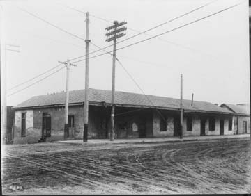
Across the street southward from the former Tononi Block was an adobe structure at the southeast pictured below with street signs of Ord and San Fernando.  Adobe homes were prevalent on these streets - settled by the early Spanish and Mexican soldiers and other persons of means in the early to mid-19th century.

Look closely at the left side for a downhill descent of Ord Street (today a walk downhill would lead to Philippe's) (Courtesy Seaver Center)
The address site of the adobe would have been about 686 North Spring.  If one walks southerly on Spring before reaching the cross street of Cesar Chavez, contemporary street life is very diversified, as shown below:


Directly across the street is the spot first introduced at the beginning image of this blog posting.  There is still a theater, though now called King Hing Theater:


The Dakin 1888 insurance atlas surprisingly reveals that in this 600 block there was a significant concentration of Chinese quarters, labeled in the atlas "Chinese" Chin. Rest." "Chinese Wash" "Chin. Board'g" "Chin. Tea" and "Chin Rooms."  These notations provide indication that Chinese resided outside of the "Old" Chinatown community.

(Click to Zoom) (Courtesy Seaver Center)
Philippe's Sandwiches

Today's best-known landmark in the area is Philippe's French-Dipped Sandwiches at 1001 Alameda Street, along Ord Street.  Back in 1888 this famous corner was a vacant lot.  Displaced from their location on Aliso Street by new freeway consruction, Philippe's moved here in 1951.


China City (est. 1938)

Across the street from Philippe's, Ord Street was the north boundary for "China City" the Chinese tourist compound created by the "mother of Olvera Street" Christine Sterling.  It opened in June of 1938, a few weeks earlier than New Chinatown's opening.  China City was partly Sterling's solution for the displaced Chinese community.  Less than a year later, a suspicious fire burned in the main section.  After being rebuilt, China City operated for about ten years before another fire brought its demise.  China City extended to Spring Street on the west, Main Street on its east side, and reaching south to Macy Street (today's Cesar E. Chavez Avenue.)

There might be a historical remnant -- at Philippe's parking lot across the street from the restaurant hangs a neon sign which reads "Shanghai Street."  Shanghai Street existed in China City so this might have been an authentic, salvaged sign.


Sonoratown

In the 19th century, the city blocks considered today's New Chinatown was home to a different ethnic group: Hispanics.  The barrio developed and resulted from demographic changes following the American period of the city after 1850. Whereas Mexican and Hispanic residents once comprised more than half the population, new Anglo settlers changed the equation. A segregated area north of the Los Angeles Plaza became inhabited by Mexicans and referred disparagingly as Sonoratown by Anglos. A study (The Los Angeles Barrio, 1850-1890 by Richard Griswold Del Castillo) delineated that the most concentrated ethnic enclave between 1872 through 1888 was the large area bounded by Main, College, Yale and Short (formerly Corta Street, about where Sunset Boulevard is today.)  Two of the main thoroughfares in Sonoratown were Castelar (today's North Hill Street) and Buena Vista (originally Calle de la Eternidad and today's North Broadway.)

Early Real Estate Subdivision Nearby

Prudent Beaudry, who served as City Mayor and who was also the developer of Bunker Hill, subdivided the hill to the west of Sonoratown about 1884.

Courtesy of the Seaver Center for Western History Research

More on New High, Ord and Spring Streets

New High, Ord and Spring may have been the fringe of Sonoratown. There was also a concentration of homes and businesses to Italians as part of L.A.'s Little Italy in the 19th century.  In 1897 and 1901, Soon Wo laundry was listed at 688 San Fernando.  In 1901, Yik Wo had a tailor business at 674 San Fernando.  In the 1909 city directory, the businesses and residents appear ethnically integrated by whites and Hispanics, without Chinese names listed. At 751 San Fernando Street was the Church of St. Peter. By 1938, New High Street (600-700 block) was mostly Hispanic, but in light of the new Chinese settlements (New Chinatown and China City) subsequent city directories showed increasing Chinese business and residential listings.

The 1943 city directory indicates these city blocks a mix of Italian, Chinese and Hispanic residents and businesses.  By 1956, the following line of businesses on Ord Street reflected the diversity:  120 Ord - Flora's; 122 Ord - F. Suie One Co. Chinese Goods; 124 Ord - Jun Quon Hin; 207 Ord - Chung Mee Cafe; 301 Ord - Juarez Cafe; 302 Ord - Lake Sun; 304 Ord - El Capricho Cafe.

At 708 New High, the corner lot sits ABC Seafood Restaurant.  Prior to their venture, the Limehouse was here.  One of their predecessors was the J.G. Medina Grocery operating in an old adobe after vacated by the El Adobe Cafe.  Click here to see a photo from the LAPL archive.


Across the street the Phoenix Inn Restaurant opened at the corner of 301 Ord Street in the year 1967, and it is still in business.


This corner has had its share of restaurant operations, including Kong Woo in 1942; Juarez Cafe in 1956.  The facade of this 1906 building has hardly change in its century-long existence.  Click here for an LAPL archival photo when it was the site of the Peluffo grocery and liquor store.

Houses of Ill Fame

Behind the brick building was another building, labeled in Dakin's 1888 insurance atlas as ILL Fame (a house of ill fame, or a brothel).  Such establishments were notorious over by Alameda and Aliso, but along these several city blocks it was commonplace, too.


(Click to zoom in) (Courtesy Seaver Center)

On New High, below Walters (Ord Street) there are at least six buildings of ill fame.  They were probably "cribs" made of small rooms.  On this street there were also two buildings for "Negro Rooms" and "Negro."

(Click to zoom in) (Courtesy Seaver Center)
The Los Angeles Times printed a "community" notice on July 1, 1889.  Various property owners supported the idea of containing prostitution houses to a single street:  along New High between Bellevue (today's Cesar Chavez Avenue) on the south and Alpine on north.  The supporters reasoned that there weren't families with children or private houses along those two blocks.

The newspaper reported on October 26, 1889 that a city order was under way to pave New High between Walters and Bellevue.  By mid-November, the paper reported a protest against paving the street.

The following year in October, a single-track railroad right-of-way was awarded; the route would travel down Buena Vista, then east onto Walters, then south onto New High.

Upper Main also had a house of ill fame, a short walk northward from the Tononi Block.

(Click to zoom in) (Courtesy Seaver Center)
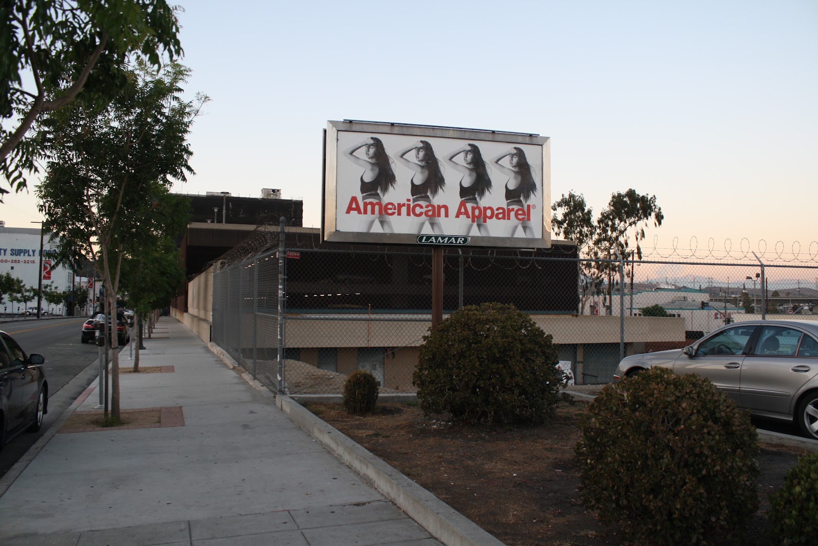
From today's perspective the site of the row of prostitution houses would have been just beyond the apropos American Apparel girls billboard:


View north on the 700 block of North Spring Street


Update 11.2.2025:

An image from the California Historical Society's Anton Wagner Photographs of Los Angeles, 1932-33. It is a view of North Spring Street, east side, along the 600 block. The building in the middle of the photo was Southern California Poultry Products, located at 686 No. Spring Street. The Tononi Block is seen in the background, in its former multi-story glory.